Google Street View has been a popular enhancement to the Google Maps system over the past few years. Street View allows us to look up places on the map, then drop into an interactive image that actually shows us that location. Google managed to create the system by sending specially designed vehicles on roads all over the country to take pictures of locations while they drove. The result is a handy tool that only further enhances the Maps programs.
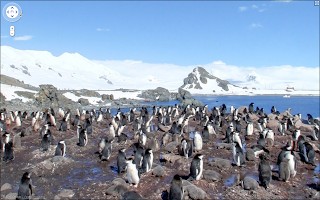
Yesterday, Google announced that Street View is now available on all seven continents, with images from Antarctica now available. But don’t worry, they didn’t send one of the vehicles down there to go rampaging through the environment, snapping photos of startled penguins along the way. Instead, Brian McClendon, VP of Engineering at Google Earth and Maps made the trip with his wife recently and took plenty of photos to add to the collection. Brian and Mrs. McClendon actually took a trek across Half Moon Island, and then shared their vacation pictures with the world.
I’m a big fan of Google Maps, and have been using it ever since it was released. Street View was kind of icing on the cake, but it is a nice enhancement. It’s kind of cool that they now have images from every continent though, but it’s making me want to visit Antarctica all that much more.
- Gear Review: The Xero Scrambler Mid is an Ultralight Hiking Shoe for Spring - March 1, 2023
- Gear Review: Yeti Roadie 48 Wheeled Cooler - August 18, 2022
- Kristin Harila Continues Pursuit of 8000-Meter Speed Record - August 16, 2022
I'm also a big fan of Google Maps and Street View! I think its just amazing that you find a random street in the middle of nowhere in the US, Europe, Japan, Australia or New Zealand and just check it out.
A while back I read an interesting blog post citing some of the benefits of Street View for hikers on A Wild Vista.
Here's a poser for those of us who like to get away from it all in the great outdoors: should Google Street View take to the mountain trails? We wrote a spoof blog post about it last January, titled Street View on Mountains with Google Sherpa-Cam
I would like to exchange links with your site adventureblog.net
Is this possible?