As many of you already know, there are a number of routes that trekkers can use to reach the summit of Kilimanjaro. Those routes include Marangu, Rongai, Lemosho, Shira, Umbwe and Machame. Each of them includes unique characteristics and features which makes them stand out from one another. For instance, the Marangu route is generally considered the easiest – relatively speaking – and features a series of huts for climbers to stay in along the way. As a result, it is often more crowded as well, which can certainly have an impact on the experience. On the other hand, the Machame route is widely regarded as the most scenic, although it is is also very challenging and steep. Each of the others have their own benefits and drawbacks, depending on the experience you most want to get out of the climb.
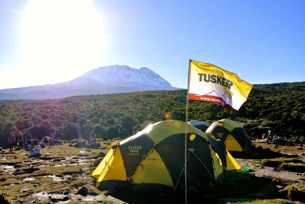
When selecting the route for the Climb for Valor, the team at Tusker Trail decided that they wanted to do something a little different. The idea was to give the climbers on our team a complete unique look at the mountain, along a route that is seldom hiked. We began by entering Kilimanjaro National Park at the Londorossi Gate and proceeding up the traditional Lemosho Route along the western flanks of the mountain. At that stage of the climb we were passing through rainforest, with the trail meandering up to our first campsite located at Mti Mkubwa at about 2795 meters (9170 ft).
The next day we continued upwards out of the forest and entered a new vegetation zone dominated by overgrown heather. At that point, we were still following the Lemosho Route up to Shira Plateau, which afforded us our first truly great look at the mountain. From that vantage point it appeared impossibly tall and still very far away, but Kilimanjaro now loomed over us, giving us a clear idea of what we had come to do. We camped that night at Shira Camp, which is located at 3505 meters (11,500 ft).
On Day three we began to divert from the Lemosho Route at last and ventured out onto the all-but abandoned Northern Circuit of the mountain. At this point, we left all other teams behind and had the trail completely to ourselves. While we weren’t exactly overwhelmed with crowds along the trail, it was refreshing to have the place to ourselves. After a full day of hiking to the Moir Camp (4164 meters/13,660 ft), Kili seemed much closer. It became abundantly clear that the summit was indeed an obtainable objective, and soon we would start to head up in ernest.
But before our summit push would begin, we had two days of acclimatization ahead. We wandered along the Northern Circuit staying at relatively the same altitude to allow our bodies time to adjust to the thin air. On our first night we stopped at the Pofu Camp (4017 meters/13,180 ft) before proceeding on to Third Cave (3963 meters/13,000 ft). These extra days were certainly crucial for getting ready for to move up higher, and I think everyone on the team was happy to have the extra time.
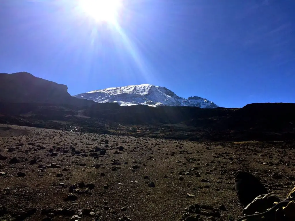
I’d be remiss in my report if I didn’t mention the scenery along the Northern Circuit. Not only did it allow us to keep an eye on Kilimanjaro at all times, it also provided fantastic views of the countryside far below. Since Kili is a stand alone mountain, there aren’t other peaks to block your view. In fact, the land around Kilimanjaro is mostly flat, which means you can see for miles in all directions. Much of the time we were actually hiking above the cloud cover, which alone made for some breathtaking scenery, but when the clouds parted you truly got a sense of just how high up we were. It was awe inspiring to the say the least.
After spending the night at Third Cave, it was time to start heading up once again. On day 6 of the climb we gained more than 760 meters (2500 ft) in altitude has we moved up to Kibo Hut at 4730 meters (15,520 ft). This would be our launching pad for the summit push the following day, and the thin air was certainly evident. At that altitude, moving too quickly could leave you out of breath, and while we were all well acclimated, everyone was feeling the effects of the thinner air none the less.
Day 7 was Summit Day at last, and while we al knew it would be a difficult challenge, the entire climbing team was ready to proceed up. Unlike most of the other squads, we set out just before dawn proceeding up and up and up. At times it felt like we would never stop climbing, as the narrow trailed wandered back and fourth towards the crater rim above us. But around noon we finally popped over the edge and arrived at Gilman’s Point. This is a major milestone for any Kili climb, as it means that you’ve reached the crater rim, and put the majority of the ascent behind you. But you’re also still two hours away from the summit as well, so the work isn’t quite done just yet.
Proceeding on from there, we hiked another hour to reach Stella Point, another important spot on Kilimanjaro. It is at that point that several routes to the summit converge as the final push to the top begins. From there, you can actually see the summit itself, even though it is still some distance off. The trek upwards transitioned onto snow at that point, which made it a bit tougher to walk, but not unbearably so.
The final approach to Uhuru Peak is a satisfying one. The final section of the climb allows you to see the famous sign on top of Kili from a long way off, although it slowly and steadily gets closer as you go. Before you know it, you’re standing on the Roof of Africa, with amazing views spread out all around you. We topped out at a little after 2 in the afternoon, and had the summit to ourselves for the entire time. This gave us the opportunity to take plenty of photos and savor the moment, despite the fact that it was a cold and blustery day on top of Kili.
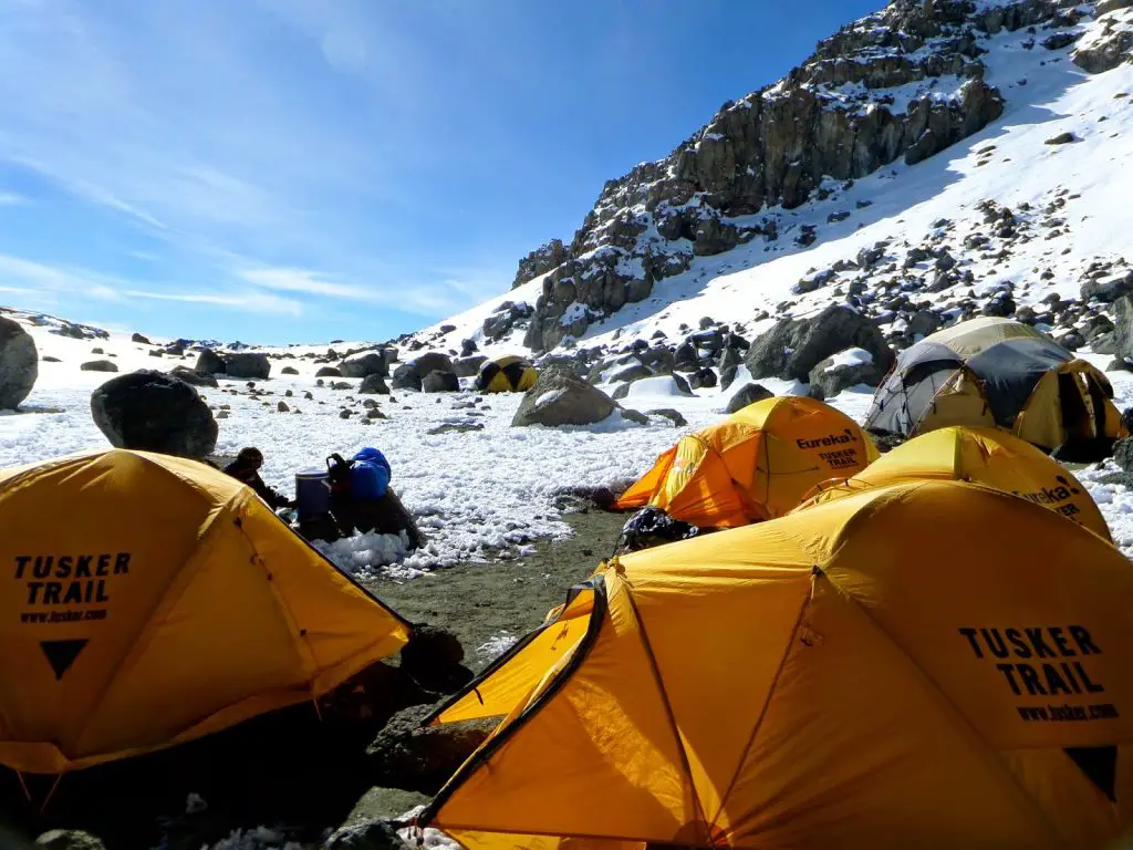
At long last we were ready to proceed down. But unlike most other teams, we were not descending very far. One of the other highlights of the Climb for Valor route was that we actually spent a night camping in the crater of the volcano. Crater Camp is located at 5700 meters (18,700 ft) on field of snow and ice. It was definitely a chilly spot to rest, but it was also a beautiful one that included some amazing views of the increasingly shrinking Kilimanjaro glaciers. There was just one other small team in the crater that night, although it truly did feel like we had the place all to ourselves.
The following day we awoke to temperatures of 15ºF/-9ºC in our tent. It had been a cold night, and while we were all warm in our sleeping bags, it was tough to climb out and face the weather. But, it was also time to start heading down, and I think it is safe to say that everyone on the team was ready to begin that process. Over the next day and a half we would descend along the Mweka Route, which is used by almost every team on the mountain. As we went down, the air became thicker, the temperature became warmer, and we all started to feel much stronger. But the descent is not one to be taken lightly. It can be very demanding on legs that are already strained from the climb up to the summit. If your legs weren’t particularly sore from the previous days of trekking, chances are they will be by the time you reach the bottom.
All told, we spent nine days on the mountain, which seems like a perfect schedule. Not only did it give us a chance to truly enjoy the beautiful scenery, but it was also ample time to acclimatize to the altitude as well. By the time we reached Mweka Gate, we were all ready for a hot shower, a comfortable bed, and a few simple amenities that we had missed out on while on the mountain. But we were also filled with a great sense of pride and accomplishment at having reached the summit as well. Tired, dirty, and immensely satisfied, we returned to Moshi to start thinking about our return home.
More to come soon!
- Gear Review: The Xero Scrambler Mid is an Ultralight Hiking Shoe for Spring - March 1, 2023
- Gear Review: Yeti Roadie 48 Wheeled Cooler - August 18, 2022
- Kristin Harila Continues Pursuit of 8000-Meter Speed Record - August 16, 2022