Google Maps has certainly been a useful item over the years. I’ve used it numerous times to navigate when in a new city or even to find things in the city I do live in. Having it on my iPhone has been a life saver on a number of occasions. For hikers, backpackers, and climbers however, the feature just became even more useful.
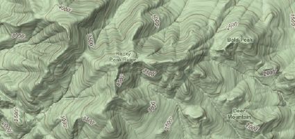
According to The Daily Dirt, one of the new blogs over at the recently redesigned Backpacker.com, Google has seen fit to add contour lines to the terrain view in Google Maps. This means that hikers can now see the changes in elevation much more accurately than before and can get a better idea of what the actual terrain is like in the area they intend to hike. Very useful indeed!
Backpacker listed the links to a few cool locations to show off the new feature, such as Yosemite and Bright Angel Trail in the Grand Canyon. Both great examples of the new feature.
- Gear Review: The Xero Scrambler Mid is an Ultralight Hiking Shoe for Spring - March 1, 2023
- Gear Review: Yeti Roadie 48 Wheeled Cooler - August 18, 2022
- Kristin Harila Continues Pursuit of 8000-Meter Speed Record - August 16, 2022
Comments are closed.