Remeasure the Height of Everest by Nepal is looking to put an end to the ongoing dispute over the exact height of Mt. Everest once and for all. This spring a team of surveyors will travel to the mountain to remeasure the height of its summit in an effort to determine its elevation as accurately as possible. The expedition has been in the works for several years now, but will finally come to fruition over the next month or so, with the results to be released in January of 2020.
According to the Kathmandu Post, the survey team will measure the height of the mountain by collecting four sets of data: precise levelling, trigonometric levelling, gravity survey, and GNSS survey. In order to do that they will need to cover 285 points with 12 different observation stations set up across Nepal.
Perhaps more importantly however, they’ll also be carrying a high tech GPS device known as a Trimble R10 to the summit. Once there, it will be installed and activated to collect precise data on that particular point on the planet. The process will take about ten minutes to complete, but should offer the most accurate measurement of the elevation after conducted.
Just how accurate will this process be? According to Nepal’s Department of Survey this process should deliver a measurement that is within centimeters of accuracy. In other words, we should know exactly how tall Everest is within a matter of a few months to an astonishingly accurate level. This should put an end to any questions regarding the height of the mountain, perhaps changing the official number that has stood for more than 60 years.
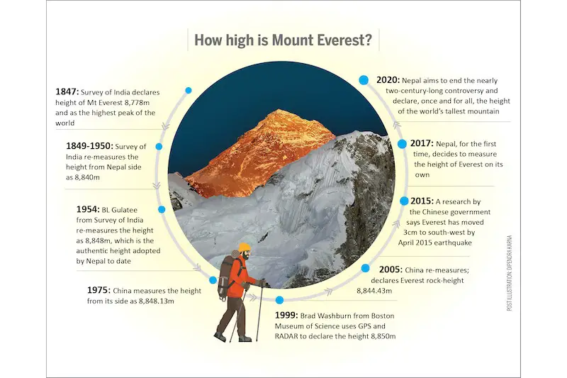
Ever since the mountain was first surveyed from a distance in the 1840s people have tried to get an accurate measurement on its height. Back then, it was estimated that Everest –– which was known as Peak XV at that time –– was exactly 29,000 feet (8839 meters) above sea level, but later surveys, conducted at closer range, determined the height to be closer to 29,029 feet (8848 meters) instead.
This included not just the rock, but the snowcap on the summit as well, but that number stood as the official elevation until 1999 when an American survey team used a GPS device to get more precise measurements, anchoring the gadget to the bedrock on the summit. Their findings indicated that the mountain was actually 29,035 feet (8850 meters), which immediately brought into question all subsequent surveys. To muddy the waters even further, the Chinese conducted their own survey in 2005, using extremely precise measuring tools. They announced that the mountain was actually 29,017 feet (8844 meters).
Of course, Nepal has a vested interest in determining just how high Everest truly is. The mountain generates a lot of money for the country on an annual basis, both with mountaineers coming to climb it and trekkers hiking in its shadow. Learning the true elevation of the peak isn’t likely to change that in any way, although there has been some speculation that K2 could actually be higher. That isn’t likely to be the outcome of this survey however and Nepal can rest assured that it will remain home to the world’s tallest peak.
The team taking the Trimble R10 to the summit is expected in Base Camp on Everest next week. From there, it will begin the long process of acclimatization and climbing to the summit.
That will likely take place around mid-May, with the rest of the data being collected in the days ahead. The Department of Survey will then spend the rest of the year collecting and analyzing that data. The plan is to finalize their report by the end of the year, with the official announcement to come in January of 2020.
- Gear Review: The Xero Scrambler Mid is an Ultralight Hiking Shoe for Spring - March 1, 2023
- Gear Review: Yeti Roadie 48 Wheeled Cooler - August 18, 2022
- Kristin Harila Continues Pursuit of 8000-Meter Speed Record - August 16, 2022