We’ve written about how a high-tech device known as lidar has helped archaeologists locate lost cities and other ancient structures in the past, but those findings were small potatoes compared to what is going on in the jungles of Guatemala at the moment. A team of researchers say that the laser-powered technology has helped them conduct the largest survey of the region ever, and what they found is simply stunning.
Lidar is typically mounted on an aircraft and uses lasers to map the surface of the planet from above. Those lasers can actually penetrate the thick jungle canopy to see what sits underneath, giving researchers a better understanding of what man-made structures may be lurking there covered by hundreds –– or even thousands –– of years of growth.
According to a new study published in Science magazine, a recent research survey completed in Guatemala was the largest use of lidar ever. When the survey was completed, archaeologists had mapped 61,480 distinct structures under the jungle canopy. Most belong to the Mayan civilization that existed in the region for more than 2500 years dating back as far as 1000 BC. or even earlier. The Mayan empire stretched across much of Central America, ranging north into Mexico and south to Belize, and beyond. But man of the structures left behind by the Maya people are located in Guatemala, and as researchers have discovered, much of it sits beneath the jungle, waiting to reveal its secrets.
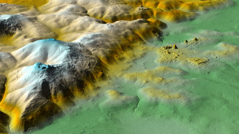
One of the more exciting findings from the survey, which was conducted in 2016 but its data is only now being completed analyzed, is the location of a new pyramid. Much like the Egyptians and Inca, the Maya also built large pyramid structures, many of which can still be found throughout Mexico and Guatemala. Researchers say that a new pyramid complex has been identified in the heart of the ancient city of Tikal, which flourished in northern Guatemala from about 300 AD to 800 AD.
In addition to the 60,000+ structures identified in the survey, the lidar scans also showed an extensive network of roads. Roughly 66 miles (106 km) have roads have been identified so far, with the routes connecting smaller towns and villages to the larger ones. Many of the cities were also said to be heavily fortified with walls and other structures. That was a surprise to the archaeologists, as was the realization that nearby wetlands were also converted for agriculture use to feed the large population.
It’s a pretty fascinating finding to be sure. Tech site Gizmodo has a good breakdown of the report for those who are interested. You can read it in its entirety here.
- Gear Review: The Xero Scrambler Mid is an Ultralight Hiking Shoe for Spring - March 1, 2023
- Gear Review: Yeti Roadie 48 Wheeled Cooler - August 18, 2022
- Kristin Harila Continues Pursuit of 8000-Meter Speed Record - August 16, 2022